Lands of the
Pharaohs, Romans, Nabateans & and Other Civilizations.
14 April to 3 May 2001
(Note: descriptions of pictures are in red)
Twenty-one days in Egypt and Jordan were filled with discovery, learning, and
enjoying the amazing results of these ancient civilizations' ability to construct
large and complex edifices that continue to amaze us. The Sphinx, Pyramids,
tombs, temples, and old cities are among the sights with which we were enthralled.
The weather was beautiful - hot and dry, and the food was international with
a flavor of the Middle East. Even though the entire US tour group on this Grand
Circle Tour consisted of 129 people, we were divided into four groups such that
we were no more than 34 people with the same guide. Our guide in Egypt, Amin,
was the best of the four by far, in our opinion, and he continued to amaze us
with his knowledge. Prior to this trip, we would have said that Greece and Rome
were the cradle of western civilization. The Greeks and Romans were the winners,
who wrote history or reported what they saw. With the ability to read the Egyptian
hieroglyphics and study their monuments and tombs, we must now try to reinterpret
that history without hindrance of our own biases and the more recent Greek,
Roman and European historians.
 This was also
the first extended trip we did with Carolyn's brother, Dick, and his wife, Christine.
Their longtime friends, Walter and Janet, provided additional insight to the
many discussions. We wouldn't object to future trip reoccurrence in our attempts
to reorient and reinterpret the chronology of history. Starting back around
Christmas in Seattle, when we started our planning, we read the books, analyzed
various opinions and had a somewhat educated view at what we were seeing in
country and what we were being told by our guides. We had a great time. The
fun-some, fear-some four-some plus two!!
This was also
the first extended trip we did with Carolyn's brother, Dick, and his wife, Christine.
Their longtime friends, Walter and Janet, provided additional insight to the
many discussions. We wouldn't object to future trip reoccurrence in our attempts
to reorient and reinterpret the chronology of history. Starting back around
Christmas in Seattle, when we started our planning, we read the books, analyzed
various opinions and had a somewhat educated view at what we were seeing in
country and what we were being told by our guides. We had a great time. The
fun-some, fear-some four-some plus two!!
Our original concern relative to visiting Egypt and Jordan was security. Normally,
as most of our friends and relatives know, we do not take tours. We plan and
do our own thing, but our concern for security in these countries tipped the
scales in favor of an organized tour. We pre-registered by e-mail our trip with
the US Embassy in Egypt and Jordan. The security we found in both countries,
however, was professional, discrete and unobtrusive. There was always a security
guard on all of our buses, two aboard ship at all times and several Tourist
Police at every dock and tourist site we visited. Someone, somewhere knew via
cell phone where our group was and where we were going at all times in both
countries. Neither country can afford to lose the tourist income. Because English
is a required language in the schools in both countries, language was never
a problem. Our contacts with the natives were always friendly and inquisitive.
"My name is Mohammad. What is yours?" was often heard. People in cars
and buses would wave and smile. In one case, a total stranger in downtown Cairo
recrossed the street to take Christine safely through the maze of moving traffic
one lane at a time.
We left New York JFK Airport on 14 April 2001 for an overnight EgyptAir Boeing
777 and arrived in Cairo the next afternoon, where we met our guide by color
code (We were in the red group.) and checked into the Cairo Ramses Hilton. We
found out that the symbol for EgyptAir is MS and stands for "missing somewhere"!
The city of Cairo is quite a place, unlike any US city. The old section of Cairo
is OLD!! The population of the city is 16 million, whereas the total for Egypt
is 70 million. Building codes and traffic rules are random to say the least!
The "new" buildings have a plethora of antennas both satellite and
regular antennas. There are traffic lights, and if you wish to obey them, that
is your choice! So traffic just goes, and goes, and goes. Rush hour is 24 hours
a day in Cairo. Ring roads and "fly-ways", another name for elevated
roads, have been built to try to move the traffic around congested areas. Friday,
the Moslem Sabbath, has less people on the road. Crossing the streets is a pedestrian
experience. You just have to get your nerve up, look for a break in the cars
in the first lane and put your foot out in the road. You then maneuver between
the other lanes of oncoming traffic as you walk perpendicular to the traffic
flow. Drivers must drive defensively, for any accident from behind is the fault
of the driver who failed to yield. There seems to be little road rage, aggressiveness,
or anxiety, as everyone yields to the other drivers. The other pedestrians are
friendly and helpful. If they see that you are stuck crossing the street, they
will help you! We found it was best to cross streets when there were other local
people crossing especially when trying to get to the sidewalks along the Nile.
We walked by ourselves on several occasions along the Nile in Cairo. No problem!
The Nile River is the longest river in the world, over 4,187 miles long. Unlike
most rivers of note, the Nile flows from south to north. Much of the water comes
from snow and monsoon rains in the Ethiopian highlands. Every year, before the
Aswan Dam was built, the Nile would flood and spread its silt over the flat
plain along the banks of the river. When the Nile receded, the farmers would
sow their seeds and the water buffalo, donkeys, mules and cattle would tramp
the seeds into the earth. No need to plow! The river is the lifeblood of Egypt.
Initially, this upside down world of going up the river by going south is confusing
for some reason. This is probably because of our Northern Hemisphere bias of
relating up with north when using maps. From Cairo south, the strip of green
that borders the Nile varies from 500 yards to several miles wide with mountains
and the Sahara beyond on both banks. For the most part, the Nile is rather clean.
However, some debris is floating along and settling out on the banks. As we
traveled the upper Nile between Karnak and Aswan on our seven-day cruise, we
mainly saw tourist traffic rather than commerce using the river. There was NO,
absolutely no aids to navigation as are seen along the rivers of the US and
Europe. Sugarcane transportation to the local refinery and rock for building
purposes downstream were the exceptions. The commercial traffic is on the highways
on both side and the railroad on the East Bank. There is little tourist traffic
between Cairo and Luxor. Most of the overnight tourist boats operate from Luxor
to Aswan. More are expected in Lake Nasser as that area expands. The Nile, of
course, is a primary source for drinking water for the Egyptians and for irrigating
the land via canals. There are also many springs in the country. Bottled water
was plentiful and cheap.
Our (red and yellow groups) hotel for the first four days was the Ramses Hilton
located at one of the busiest intersections in Cairo,
right on the Nile and across the intersection from the Egyptian 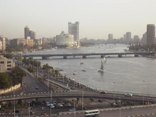 Archeological
Museum. The other half of the total group (blue and green) was quartered in
the Sheraton across the river. We walked along the Nile observing the various
feluccas, which are sailboats with large trapezoid sails and riverboats. Observing
the local people, while strolling along the walkway and getting our bearings,
was quite different from the many western countries we have visited. Access
to the Archeological Museum was rather easy. We only had to cross four lanes
of traffic and find the pedestrian tunnel under the other 8-16 lanes of traffic.
The museum is very security conscious and all visitors must have their hand
packages scanned and the visitor passes through an electronic device like at
the airports. The museum contains a fabulous collection where you can spend
hour upon hour or day upon day. Our tour group had a guided tour for three hours,
but we returned by ourselves on a free afternoon for two more hours. The museum
was built in 1903 under the sponsorship of August Mariette who was a prominent
archeologist. Exhibits include a copy of the Rosetta Stone, found in 1799 in
north Egypt on the Rosetta branch of the Nile; and King Tutankhamun's gold and
other funerary items, including full size chariots of many 18th Dynasty pharaohs
including Amenhotep, Nefertiti, and Queen Hatshepsut. Other artifacts, such
as holy boats, and little statues of servants (one for each day of the year
to take care of the daily needs of the pharaoh) were found at the Egyptian temples.
The translation of the Rosetta Stone was the beginning of Egyptology, since
the translation provided the key to the hieroglyphics found in the tombs and
temples. A Frenchman, Champollion, broke the code and three thousand years of
lost history with names and places and dates could be read and understood. Even
the statues and paintings could "talk" after the code was broken.
When you look at an Egyptian statue, for instance, a curl in the beard and the
legs are together, means the person is dead. If the beard is straight and a
leg is forward, the person was alive when the statue was made. Too many legs
on a painting could mean motion or some quantity of people. Boomerangs, spears
and bow & arrow were used to hunt in the 2,500 BC time period. The first
"sofa-bed" is the folding campaign bed of King Tut with hinges for
folding. Many coffins had eight layers with the inner most one being solid gold,
the symbol for eternity. We saw the fantastic exhibit of the gold of King Tut,
which will no longer be "traveling" for the insurance is much too
high. Much of the gold was mined in the southern Nubia area now under Lake Nasser.
Egypt has plans to build a new Egyptian Museum next to the pyramids where land
is presently available. Center city land is too expensive and the current building
is bulging from all of the treasures.
Archeological
Museum. The other half of the total group (blue and green) was quartered in
the Sheraton across the river. We walked along the Nile observing the various
feluccas, which are sailboats with large trapezoid sails and riverboats. Observing
the local people, while strolling along the walkway and getting our bearings,
was quite different from the many western countries we have visited. Access
to the Archeological Museum was rather easy. We only had to cross four lanes
of traffic and find the pedestrian tunnel under the other 8-16 lanes of traffic.
The museum is very security conscious and all visitors must have their hand
packages scanned and the visitor passes through an electronic device like at
the airports. The museum contains a fabulous collection where you can spend
hour upon hour or day upon day. Our tour group had a guided tour for three hours,
but we returned by ourselves on a free afternoon for two more hours. The museum
was built in 1903 under the sponsorship of August Mariette who was a prominent
archeologist. Exhibits include a copy of the Rosetta Stone, found in 1799 in
north Egypt on the Rosetta branch of the Nile; and King Tutankhamun's gold and
other funerary items, including full size chariots of many 18th Dynasty pharaohs
including Amenhotep, Nefertiti, and Queen Hatshepsut. Other artifacts, such
as holy boats, and little statues of servants (one for each day of the year
to take care of the daily needs of the pharaoh) were found at the Egyptian temples.
The translation of the Rosetta Stone was the beginning of Egyptology, since
the translation provided the key to the hieroglyphics found in the tombs and
temples. A Frenchman, Champollion, broke the code and three thousand years of
lost history with names and places and dates could be read and understood. Even
the statues and paintings could "talk" after the code was broken.
When you look at an Egyptian statue, for instance, a curl in the beard and the
legs are together, means the person is dead. If the beard is straight and a
leg is forward, the person was alive when the statue was made. Too many legs
on a painting could mean motion or some quantity of people. Boomerangs, spears
and bow & arrow were used to hunt in the 2,500 BC time period. The first
"sofa-bed" is the folding campaign bed of King Tut with hinges for
folding. Many coffins had eight layers with the inner most one being solid gold,
the symbol for eternity. We saw the fantastic exhibit of the gold of King Tut,
which will no longer be "traveling" for the insurance is much too
high. Much of the gold was mined in the southern Nubia area now under Lake Nasser.
Egypt has plans to build a new Egyptian Museum next to the pyramids where land
is presently available. Center city land is too expensive and the current building
is bulging from all of the treasures.
Most of our meals were either provided at the hotel or on the ship. Primarily
our meals, served buffet style, were international, with some Egyptian food.
A unique breakfast food was fuul, which is mashed fava beans usually ladled
into a bowl and topped with oil, tahini, or hot peppers. Lunches and dinners
had salad bars with tahini, yogurt, humus, chickpea salad, corn salad, tomato
salad, beet salad, and goat cheese. Soaps were plentiful. Entrees included rice,
vegetables, chicken, ground lamb, beef and fish done in various ways. Desserts
were plentiful with mousses, cakes, tarts, ice cream, and cream puffs. We all
drank a lot of bottled water that was either provided with meals or we purchased
at local markets. Tea and coffee were available.
Two evening dinners in Cairo were special meals. Along the Nile, there are
riverboats functioning as restaurants. The Le Pacha was directly across the
Nile from the Ramses Hilton Hotel and our group had a typical Egyptian meal
consisting of appetizers of tahini, grape leaves, humus, falafel, fried cheese;
entrée was mixed grill of chicken, lamb, beef and rice and for dessert
we had four different cakes, including baklava. Another night an Egyptian family,
Mr. and Mrs. Hassan, (upper middle class) hosted our group in their home. Our
bus group of 20 was split into two groups and visited with two families in the
same building. All the families in this building were related to Mrs. Hassan.
The bus dropped us off at the corner for the street was too narrow for the bus.
We arrived at the apartment building, which was a plain, non-descript building
with a small elevator attached to the outside. However, the elevator was key
operated, so we all walked up the three or four flights to the apartments. As
we entered the apartment, we were amazed at the beauty and spaciousness. The
entry way led us into four large "living" rooms. Highly polished wood
floors varnished with polyethylene, antique Victorian furniture, fireplace,
large sliding glass windows, and curtains with rich red velvet drapes. The 11
of us gathered in one of the living rooms richly furnished with Victorian furniture.
Two 15-year old twin boys sat and talked with us. We asked lots of questions
and they very generously answered them. The boys spoke excellent English. However,
the mother didn't speak much English at all and was really not part of the conversation.
Their older sister was on a shopping trip to Istanbul with an Aunt. The aim
of both of the boys was to get to Disneyland and attend college in the US. Until
the food was served, their mother was not in the room, but instead was supervising
the preparation and serving of the food. After dinner, she joined us and the
boys translated for their mother. Mr. Hassan wasn't available for the evening.
The boys attend a private school in Giza and both like math and biology. We
had four biologists in our group! Our dinner, served buffet style, consisted
of zucchini with béchamel sauce, rice, beef with mushrooms and peppers,
chicken stewed with peppers and potatoes, tomatoes/cucumbers, dolmades, fried
pita with yogurt, and fresh pita. Dessert was a pudding and chocolate cake.
This was an extraordinary special time to spend with a very interesting Egyptian
family in their home.
Cairo, including Heliopolis, is on the east bank of the Nile and Cairo, including
Giza, is on the west bank. The Pyramids and Sphinx are in Giza. A 45-minute
drive from our hotel took us to the outskirts of Cairo and to the Giza plateau
where the Pyramids and Sphinx are located. The city sprawls uncontrollably in
all directions - farms, small family plots of land, and unorganized buildings.
Goats, donkeys, and sheep all roam in these suburbs of Cairo. A wall has been
built to retain the push of the city toward the Sphinx, but population control
is the biggest problem facing the economic development of Egypt. Every eight
months a million new mouths need to be fed. Consequently, the growth around
the Cairo area is booming. Buildings are built and left unfinished with rebar
sticking out of the top surrounded by TV satellite antennas. Since finishing
costs are high, the money is spent on the inside rather than the outside of
the building. Our guide told us that many times people buy their apartments
as "shells" and they finish them with plumbing, electrical, painting,
windows, etc, over a period of years. Our guide bought his shell eight years
ago in Heliopolis for $35,000 and has spent the time finishing it with the hope
of completion within this year. The housing cost in Heliopolis is two to four
times more expensive and if located near the Nile River is five to ten times
more expensive than Cairo in general. Government schools are free and children
attend for one-half day six days a week. Private school children attend five
full days a week and have Friday and Sunday as their weekend. All study English
from the age of five and grades influence which university they can attend.
Egypt's free education system, including 17 universities, produces many doctors,
lawyers, professional people, and health care people, however, there are not
enough jobs for them (15% are unemployed). Electricians, plumbers and carpenters
are the high paid professions. In many cases, educated Egyptians leave the country
and go to other Middle East countries to work. Otherwise, they are forced to
secure a job below their education level. Automation is not a priority. The
important matter is for people to have jobs, all kinds of menial jobs. Harvesting
the crops by hand requires more people than if the process was automated. People
pay to have work done, you are not your own handy man, you don't do work for
yourself…this creates jobs. Work takes a long time to complete for they
don't have the proper tools and supplies. The government is encouraging more
people to learn vocations such as plumbing, electrician, for that is where the
shortage occurs. Payment for a menial task or kindness, even for the person
handing out the toilet paper at rest rooms, is part of the economy.
The tour arranged for our group to talk with an American lady, Colette, who
married an Egyptian and has been living in Cairo for several years. She related
the trials and tribulations of getting her apartment painted and decorated.
Selecting a paint color is not as easy as going to the store and picking out
a paint chip. Instead, the painter brings a large bucket of white paint and
proceeds to mix little batches and put it on the wall for your concurrence.
Two days later Colette was satisfied with one of the colors! She had brought
sticky wall hangers for hanging pictures from the US, but the concrete-plaster
walls were not smooth so they would not work. She related a funny story about
drilling holes in the wall to hang a picture. The man came with a drill, which
had no plug, just the twisted wire ends. Electrical outlets are not standard
and the adapters are always lost, so it is easier to cut off the plug, twist
the wires and stick the wires into the socket. The man didn't have an extension
cord to reach the wall where the hole was to be drilled. What did he do…run
the drill for several seconds, then run to the wall, of course pulling the wire
right out of the socket. This was repeated several times until finally the hole
was drilled in the wall. Colette related several other interesting living experiences.
The economic class is flexible and you can move between different classes, however,
the social class is fixed, you always associate with the same people-mostly
related. Cairo is a village and wherever you go you always see the same people.
An invitation to dinner means you arrive no earlier than 10 pm and eat at 1
or 2 am, then go home. No, our dinner at the Hassan home was at 7 pm, not 1
am! Egyptians believe that fate controls their lives - "In Sha'Allah"
- or God willing is used many times in all conversations. Egyptian people are
a social and helpful people. However, people don't know where they are or how
to direct you to another location. The police especially don't know for they
are brought in from rural areas and are given an assignment, so they couldn't
tell you how to get from point A to point B in the city.
Egypt's biggest export is date palm with cotton as the main crop of the northern
delta region. Economic income is oil, the Suez Canal fees, tourism, agriculture,
and over 8 million Egyptians working abroad sending money home. Egypt is pretty
much self sufficient in food products, except they import about 30% of their
wheat from Australia. Beasts of burden are used instead of tractors in most
cases to harvest the crops. Children in rural areas learn a craft such as carpet
weaving. Because of the population explosion, the school systems can't handle
the quantity and run two sessions a day. Therefore, children go to school for
just a half-day and the other half day, from age nine on, work in the carpet
factories where they are paid ten Egyptian pounds/day ($2.50) and receive a
meal. We visited one of these carpet factories and saw how the carpets were
made using camel hair, wool, and silk. The kids seemed happy, but the whole
affair did not seem right. Kids were working at a menial task! One square meter
of 20 knots/cm2 takes two months to complete.
We begin our tour at the archeological sites near Cairo. Saqqara or Sakkara
, just about 10 miles south of Giza on the west bank, is the large necropolis
that for over 3,000 years, starting about 2,500 BC, served Memphis, an ancient
Egyptian capital as a burial area. Saqqara is on the edge of the Sahara desert.
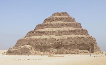
Inhotep, a high priest of Heliopolis, built the six-tiered
Ziggurat, a 200-foot tall "Step" Pyramid for the Pharaoh Djosor (Zoser).
 This
is the only large pyramid in Egypt that was really a tomb. The design was developed
from early mastoba tombs. Inhotep is considered to be the Father of Pyramidology.
The visitor enters the Saqqara area via the Hypostyle Hall, which consists of
painted columns representing palm trees, and each set of two columns guard one
of the 42 shrines. The enclosure wall around this entrance area had 14 entrances,
of which only one was the "real" entrance. Standing in the plaza area,
we admired the size and complexity of this Step Pyramid. Nearby is where the
Pyramid Texts were found in the "Pyramid" (really a mound) of Unas,
a Pharaoh who died about 2,323 BC. Inside the tomb of Unas the walls are decorated
with colorful scenes of men carrying ducks, gods, and other animals. Colors
are still visible and vibrant after 5,000 years. The Pyramid Texts provide the
earliest prehistory knowledge of the Egyptians. The texts are long columns of
inscribed hieroglyphics that refer to the use of iron, a rare metal to the Egyptians.
The texts disclose a vanished world of thought and speech, hymns and prayers,
and a glimpse of high intelligence and technology that existed prior to the
beginning of the pharaohic period and we would like to do further reading of
the translations. The star Sirius and the yearly cycle are referred to in the
Pyramid Texts. The Sothic or Sirian cycle is the periodic return of the helical
rising of Sirius, which appears just ahead of the sun's rising. This period
is 365.25 days or only 12 minutes longer than the earth's solar year. Sirius
is, in fact two stars, Sirius-A and Sirius-B, a dwarf star that revolves around
Sirius-A every 50 years.
This
is the only large pyramid in Egypt that was really a tomb. The design was developed
from early mastoba tombs. Inhotep is considered to be the Father of Pyramidology.
The visitor enters the Saqqara area via the Hypostyle Hall, which consists of
painted columns representing palm trees, and each set of two columns guard one
of the 42 shrines. The enclosure wall around this entrance area had 14 entrances,
of which only one was the "real" entrance. Standing in the plaza area,
we admired the size and complexity of this Step Pyramid. Nearby is where the
Pyramid Texts were found in the "Pyramid" (really a mound) of Unas,
a Pharaoh who died about 2,323 BC. Inside the tomb of Unas the walls are decorated
with colorful scenes of men carrying ducks, gods, and other animals. Colors
are still visible and vibrant after 5,000 years. The Pyramid Texts provide the
earliest prehistory knowledge of the Egyptians. The texts are long columns of
inscribed hieroglyphics that refer to the use of iron, a rare metal to the Egyptians.
The texts disclose a vanished world of thought and speech, hymns and prayers,
and a glimpse of high intelligence and technology that existed prior to the
beginning of the pharaohic period and we would like to do further reading of
the translations. The star Sirius and the yearly cycle are referred to in the
Pyramid Texts. The Sothic or Sirian cycle is the periodic return of the helical
rising of Sirius, which appears just ahead of the sun's rising. This period
is 365.25 days or only 12 minutes longer than the earth's solar year. Sirius
is, in fact two stars, Sirius-A and Sirius-B, a dwarf star that revolves around
Sirius-A every 50 years.
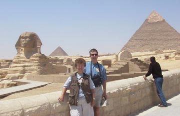
The Sphinx and three Pyramids of Giza, Khufu (Cheops)
or 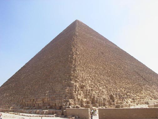 Great
Pyramid, Khafre (Chephren) and Menkataure (Mycerinus), are the most
famous structures of ancient Egypt. The pyramids each have an Egyptian and a
Greek name as a result of the "Who wrote the history?" conflict. Our
guide relates the traditional story of how the pyramids were built around 2,500
BC yet, we wonder about their relationship to the stars of Orion's belt, Al
Nitak, Al Nilam and Mintaka. The pyramids are not built in a straight line.
In fact, the three pyramids are exactly aligned with the
three stars in Orion's belt and two other pyramids (Zawiyet el Aryan (SW) and
Abu Ruwash (NE)) have been recently found to correlate exactly with the arrangement
of two other stars in the Orion Constellation around 10,450 BC. With the
Nile River as a substitute for the Milky Way, what exists in the Cairo area
is a map of the sky of the Northern Hemisphere. Another point of interest is
the location on earth of the Great Pyramid. The site is the geographic center
of the landmass of the earth and north south and east west lines through the
site divide the earth's landmass into four equal areas. How did these ancient
people know that?
Great
Pyramid, Khafre (Chephren) and Menkataure (Mycerinus), are the most
famous structures of ancient Egypt. The pyramids each have an Egyptian and a
Greek name as a result of the "Who wrote the history?" conflict. Our
guide relates the traditional story of how the pyramids were built around 2,500
BC yet, we wonder about their relationship to the stars of Orion's belt, Al
Nitak, Al Nilam and Mintaka. The pyramids are not built in a straight line.
In fact, the three pyramids are exactly aligned with the
three stars in Orion's belt and two other pyramids (Zawiyet el Aryan (SW) and
Abu Ruwash (NE)) have been recently found to correlate exactly with the arrangement
of two other stars in the Orion Constellation around 10,450 BC. With the
Nile River as a substitute for the Milky Way, what exists in the Cairo area
is a map of the sky of the Northern Hemisphere. Another point of interest is
the location on earth of the Great Pyramid. The site is the geographic center
of the landmass of the earth and north south and east west lines through the
site divide the earth's landmass into four equal areas. How did these ancient
people know that?
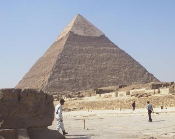
 The
Pyramids lie on a hill above the Sphinx. This fact is not obvious
when you are looking at most pictures of the site. The Great Pyramid of Khufu
is the largest pyramid and the 31-foot conical point at the top and the outer
finishing stone were quarried and are missing. The Great Pyramid is sited not
exactly at 30 o N latitude (29o 58' 22") to account for atmospheric refraction
whereas the true position is 29o 58' 51". The ratio of height to circumference
of the Great Pyramid equals 6.28 or two times pi. Interestingly, the Pyramid
of the Sun at Teotihuacan in Mexico incorporates 4 pi. The builders in both
cases had a fundamental understanding of mathematics.
The
Pyramids lie on a hill above the Sphinx. This fact is not obvious
when you are looking at most pictures of the site. The Great Pyramid of Khufu
is the largest pyramid and the 31-foot conical point at the top and the outer
finishing stone were quarried and are missing. The Great Pyramid is sited not
exactly at 30 o N latitude (29o 58' 22") to account for atmospheric refraction
whereas the true position is 29o 58' 51". The ratio of height to circumference
of the Great Pyramid equals 6.28 or two times pi. Interestingly, the Pyramid
of the Sun at Teotihuacan in Mexico incorporates 4 pi. The builders in both
cases had a fundamental understanding of mathematics.
The Giza pyramids were the end products of accumulated architectural and engineering
experience. No pyramids of comparable quality were built before or thereafter
and few of those WERE TOMBS. However, despite the Egyptologist
and tourist literature, there no evidence of a burial tomb in any of the Giza
pyramids since no inscriptions, paintings, or funeral objects were found. Yes,
there are chambers inside, but no one was buried in them. The Khafre
pyramid still has the limestone facing on the top part of the pyramid,
 which
wasn't pillaged to build other structures. The outer covering for the other
pyramids was totally pillaged. On the tour we were able to walk down into the
mistakenly called "burial" chamber of the Menkaure (smallest) pyramid.
We were fortunate to have free time at the end of the Nile cruise and returned
to the pyramids to study them more in-depth. A small number of people (150/day)
may tour the inside of the Khufu pyramid and, unfortunately, we didn't get there
early enough on our free day to get tickets. The Great Pyramid has 203 courses
and the height of each course is about 2 ¼ feet. The height is 481.3949
feet with a base perimeter of 3,023.16 feet.
which
wasn't pillaged to build other structures. The outer covering for the other
pyramids was totally pillaged. On the tour we were able to walk down into the
mistakenly called "burial" chamber of the Menkaure (smallest) pyramid.
We were fortunate to have free time at the end of the Nile cruise and returned
to the pyramids to study them more in-depth. A small number of people (150/day)
may tour the inside of the Khufu pyramid and, unfortunately, we didn't get there
early enough on our free day to get tickets. The Great Pyramid has 203 courses
and the height of each course is about 2 ¼ feet. The height is 481.3949
feet with a base perimeter of 3,023.16 feet. 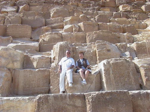 Huge
blocks of stone form the base of the pyramids, each block weighing about 15
tons or more, while the average blocks weighs 2.5 tons. Using
the steps for access to the interior, we could climb up the several courses
of the pyramid and have our picture taken sitting among these huge finished
boulders! To level the site, the builders had quarried out the bedrock
stone to a depth of about twenty-five feet from the western and northern sides.
We noticed that the northwest and southwest corner of the Khafre pyramid were
carved from bedrock. We could not see a seam in the first 3-4 courses of each
of these bedrock "corner stones", which were connected by cut blocks
along the west side of the pyramid. Around the Khafre pyramid, there are also
lots of eight sided stone "wheels" that have been cut and dressed
with grooves on each face. Think of a wheel two feet thick with a five-foot
diameter and around the outside circumference there is a groove on each of the
eight faces. On each face are three-inch deep notches about every eight inches
inside this groove. We couldn't at first figure out the purpose of these stones
for we saw hundreds of them either whole or broken in pieces. They were not
pilfered as were most finished stone blocks that were quarried from all sides
of the structure. Our guess, based on what we saw, was that these "wheels"
were the bottom course of the pyramid and were set into protruding fixtures
from the inner course like wheels and the finished outer stone was then attached
using the outer notches.
Huge
blocks of stone form the base of the pyramids, each block weighing about 15
tons or more, while the average blocks weighs 2.5 tons. Using
the steps for access to the interior, we could climb up the several courses
of the pyramid and have our picture taken sitting among these huge finished
boulders! To level the site, the builders had quarried out the bedrock
stone to a depth of about twenty-five feet from the western and northern sides.
We noticed that the northwest and southwest corner of the Khafre pyramid were
carved from bedrock. We could not see a seam in the first 3-4 courses of each
of these bedrock "corner stones", which were connected by cut blocks
along the west side of the pyramid. Around the Khafre pyramid, there are also
lots of eight sided stone "wheels" that have been cut and dressed
with grooves on each face. Think of a wheel two feet thick with a five-foot
diameter and around the outside circumference there is a groove on each of the
eight faces. On each face are three-inch deep notches about every eight inches
inside this groove. We couldn't at first figure out the purpose of these stones
for we saw hundreds of them either whole or broken in pieces. They were not
pilfered as were most finished stone blocks that were quarried from all sides
of the structure. Our guess, based on what we saw, was that these "wheels"
were the bottom course of the pyramid and were set into protruding fixtures
from the inner course like wheels and the finished outer stone was then attached
using the outer notches.
The Barque Museum is on the south side
of the Khufu pyramid. 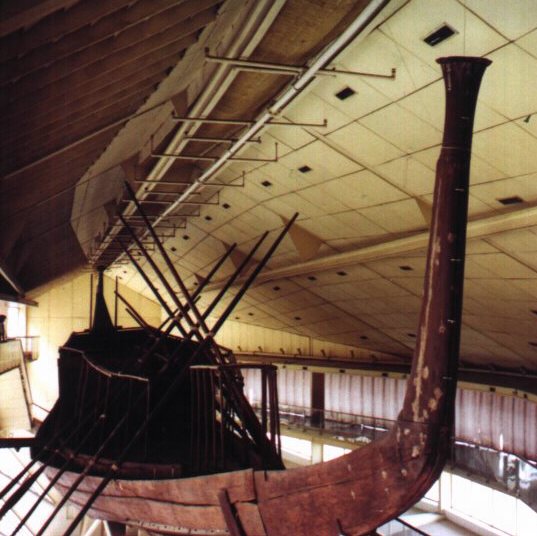 Archeologists
have found five long pits, which each contained a cedar wood boat.
They believe they were used to carry the pharaoh's body across the Nile to the
Valley Temple where the body was then transported to a tomb in the pyramid.
The wood was obtained from Lebanon. The boats were then buried around the pyramid
to provide transport for the king into the next world. Two large boats were
found in two separate pits in 1956, on the southern side of the Pyramid Khufu.
One is 100 feet long and the other is 141 feet, both have a 40-ton displacement!
The ship in the museum is obviously designed for ocean travel and not just Nile
River usage because of the inherent flexibility and keel design. Nile boats
have little use for a keel. In addition to the sail, twenty-four oarsmen rowed
and twenty-four oarsmen were on deck resting. Visitors to the museum must wear
covers over their shoes. On the first level of the museum is the burial pit
and some of the covering stones (about 15' long, 3' wide and 5' high) and a
small model of the boat; the second level has a walkway around the actual boat.
About 40 of the HUGE covering stones were needed to cover and
seal the pit holding the boat. Each stone was cut to fit into adjoining sockets
in the bedrock around the top of the pit.
Archeologists
have found five long pits, which each contained a cedar wood boat.
They believe they were used to carry the pharaoh's body across the Nile to the
Valley Temple where the body was then transported to a tomb in the pyramid.
The wood was obtained from Lebanon. The boats were then buried around the pyramid
to provide transport for the king into the next world. Two large boats were
found in two separate pits in 1956, on the southern side of the Pyramid Khufu.
One is 100 feet long and the other is 141 feet, both have a 40-ton displacement!
The ship in the museum is obviously designed for ocean travel and not just Nile
River usage because of the inherent flexibility and keel design. Nile boats
have little use for a keel. In addition to the sail, twenty-four oarsmen rowed
and twenty-four oarsmen were on deck resting. Visitors to the museum must wear
covers over their shoes. On the first level of the museum is the burial pit
and some of the covering stones (about 15' long, 3' wide and 5' high) and a
small model of the boat; the second level has a walkway around the actual boat.
About 40 of the HUGE covering stones were needed to cover and
seal the pit holding the boat. Each stone was cut to fit into adjoining sockets
in the bedrock around the top of the pit.
After our visit to the Solar Barque, we walked down the steep hill. The Sphinx
was built along the Nile delta where the river would rise each spring. All of
the pictures we had seen of the site have distorted the geographical facts.
The Sphinx and the pyramids were not built on the same level. The Sphinx is
at the bottom of the plateau which rises up rather steeply to the level of each
of the pyramids. The base of the pyramids was quarried from the bedrock to level
the building site. Why is the Sphinx a lion figure? The Age of Taurus, the Bull,
was 4,000 to 2,000 BC. In our opinion from what we had read and from our own
onsite observations, the body of the Sphinx was carved from bedrock about 10,500
BC and not during the 2,500 BC period as claimed by the Egyptologists. This
is one of the two main dating problems we have with the Egyptologists. The Sphinx
looks to the east and, at the summer solstice around 10,500 BC, the constellation
in view behind the rising sun was Leo, the Lion. As we walked around the Sphinx,
we observed the extensive water erosion marks on both the Sphinx and the surrounding
three sided enclosure wall. Robert Schoch, a geologist, stated that the Sphinx
was eroded by long-term rain, not wind. An erosion expert, John Anthony West,
confirmed this opinion. We noted how easily the enclosure could and did become
filled with sand on several occasions since construction. Several pharaohs claimed
to restore the Sphinx during their reign and credible historians, for example
Herodotus and Diodorus Siculus, have recorded since at least 500 BC the condition
that they had observed. Herodotus never mentions the Sphinx, but makes a lot
of observations and comments on the Pyramids. The fact is that the body of the
Sphinx was probably buried at least half of the time since the 2,500 BC time
period and during that time the area did not receive enough rain to cause the
observed erosion. The site did, however, receive a large amount of rain during
the sixth to eighth millennium BC. The text of the Inventory Stella in the Cairo
Museum clearly indicates that both the Great Sphinx and Pyramid were in existence
long before Khufu and that the structure was dedicated to the goddess of magic
and not to Khufu. The Sphinx Stella (Where is it?), erected by Thutmosis IV,
stated he had restored the Sphinx and paid tribute to an earlier restoration
by Khafre indicating the Sphinx was already old and Khufu did not build the
pyramid. Like Ramesses II (sometimes spelled Ramses), many pharaohs took credit
for what was done prior to their reign. Rewriting history seems to be an obsession
for historians. To confuse the literate, names have several different spellings
because the English is a phonetic translation of the Arabic or hieroglyphics
or Greek or what-ever.
The head of the Sphinx originally was most
likely a large natural limestone protrusion that was carved. From the site where
the 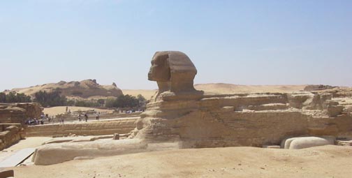 Sphinx
is located, we could see several other natural limestone protrusions like the
one that was used to form the head. In front of the Sphinx are the Sphinx Temple
and the Valley Temple. We got to the Sphinx south side overview area through
the Valley Temple. This temple is far older than the adjoining structures and
was built using the megalithic limestone blocks (weighing over 200 ton) quarried
from the bedrock around the body of the Sphinx. The walls of this temple are
constructed like Machu Picchu in Peru, i.e. large irregular, but carved stone
blocks that fit together perfectly for earthquake survival. The outer walls
also show immense water erosion. The surprising fact about the Sphinx is the
non- proportional ratio of the width to the height. The body, especially toward
the flanks, is narrower than we expected, probably because of erosion, and the
many attempts at restoration have further complicated the problem. A comparison
of other sphinx statues emphasizes this difference in proportion. The Sphinx
is big, but not as big as pictures lead you to believe. When you stand above
looking down into the "moat" surrounding the Sphinx, a different perspective
becomes obvious.
Sphinx
is located, we could see several other natural limestone protrusions like the
one that was used to form the head. In front of the Sphinx are the Sphinx Temple
and the Valley Temple. We got to the Sphinx south side overview area through
the Valley Temple. This temple is far older than the adjoining structures and
was built using the megalithic limestone blocks (weighing over 200 ton) quarried
from the bedrock around the body of the Sphinx. The walls of this temple are
constructed like Machu Picchu in Peru, i.e. large irregular, but carved stone
blocks that fit together perfectly for earthquake survival. The outer walls
also show immense water erosion. The surprising fact about the Sphinx is the
non- proportional ratio of the width to the height. The body, especially toward
the flanks, is narrower than we expected, probably because of erosion, and the
many attempts at restoration have further complicated the problem. A comparison
of other sphinx statues emphasizes this difference in proportion. The Sphinx
is big, but not as big as pictures lead you to believe. When you stand above
looking down into the "moat" surrounding the Sphinx, a different perspective
becomes obvious.
Sadly civilization is quickly encroaching upon the Giza plateau. About 100
meters from the Sphinx is a Pizza Hut and KFC! When there are many tourists
on the site, there are many merchants hawking their wares, wanting to give you
a ride on a camel, wanting you to take their picture or sell you something.
Everywhere you turn, "they" are asking for money. A tourist can't
take a picture without getting someone with his or her hand out. On our first
visit, we were so bothered by the constant hassling that it was uncomfortable.
When the three of us returned on our own, a week later, there were fewer tourists
and the merchants weren't as persistent and left us alone. One of the first
Arabic words we learned is "la ah" meaning NO. A waving hand, palm
down is also a deterrent.
After our visit to the pyramids camel rides were available. About half of our
group opted to take a 10-minute ride. We have two great pictures of John on
his camel! In the evening, we saw the sound and light show at the pyramids -
not a great show. A sandstorm was beginning, so there was a lot of sand in the
air, which distorted the laser beams.
Old Cairo or Coptic Cairo is an interesting section of the city. About 640
AD, Arabs settled the oldest part of Cairo. The oldest mosque was built shortly
after. This area now contains over 20 old churches, 20 old mosques, and one
old synagogue. Ben Ezra, which isn't in use today, is thought to be built on
the site where Moses prayed before leaving Egypt. A 7th century AD Christian
church was built on that site and closed in the 9th century because of high
taxes. In 1,115 AD, the Jewish people took the church back and converted to
a synagogue. We visited the Church of Abu Sarga whose crypt is thought to be
where the holy family stayed. The crypt is now flooded because of the high water
table in the entire Nile delta. Major water diversions are being constructed
in Old Cairo to counter the problem supposedly caused by the building of the
Aswan dam. We also visited the Hanging Church built on top of a 1st century
Roman ruin. Twelve to fifteen per cent of the Egyptians are Coptic Christians
and many hold key positions in the government.
Unfortunately, we could not visit the Labyrinth at Hawara near Lake
Moeris (southwest of Giza) in the Faium Basin. The site is believed to be the
Avaris of the South? In our opinion, Joseph built this storage complex, when
he was the Vizier of Amenemhut III (Nimaatre), to store the food for the famine
caused by the 21-meter and higher floods of the Nile. Herodotus describes the
labyrinth as having two stories and over 3,000 rooms. The Egyptians, of course
did not use meters as a measure. Cubits were the measure of distance in Egypt.
However, in at least three temple complexes along the Nile, we saw what are
called Nileometers. The local tax rate was set by the height of the river at
spring flood during pharaoh times. Avaris/Pi-Ramese was the Avaris of the North
(northeast of Giza) in the Nile delta where Joseph also built a storage complex
and later settled and died. The construction of the extensive storage capability
was part of the creation of three regional departments of state and a reorganization
of the Joseph administration by Amenemhut III.
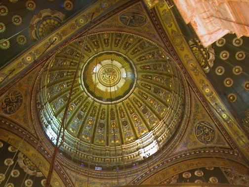 When
we returned to Cairo after our seven-day Nile cruise, we visited the Salah Al
Din Mosque and fortress which was built in the 12th century AD. This is the
largest citadel in the Islamic world and was built, but never used, to defend
the country during the Crusades. Later, the citadel was used as a ruling palace
until the 19th century. The mosque's design is similar to the Blue Mosque of
Istanbul. The dome ceilings are beautiful and required
eight years to complete. Mohammad Ali at one time was the head of
the Royal family of Egypt and he is buried here in the mosque. The five tenets
of Islam are there is one God and that is Allah; pray five times a day - dawn,
morning, noon, afternoon, evening; observe Ramadan; go to Mecca at least once;
and give to the poor. We flew from Cairo to Luxor in a Egypt Air Airbus A300
and boarded our 18-month-old ship, MS Nile Ruby. The ship accommodated our entire
group of 129 passengers. There are about 200 registered tourists ships on the
Nile, thus at each dockage there are three to four moored or rafted together.
Passengers access their boat by walking through the foyer of the other boats.
The old section of the Luxor area is actually three separate areas: the city
of Luxor and the village of Karnak on the east bank, and the monuments and necropolis
of ancient Thebes is on the west bank of the Nile. The Egyptians were consistent.
They lived on the East Bank and were buried on the West Bank. Amenophis III
was one of the first builders of the Luxor Temple. The Temple is made of sandstone
and dedicated to Amun-Ra (sun god). Originally, the Luxor Temple complex was
connected to the Karnak Temple complex via a two-mile long avenue flanked by
sphinx statues about every twenty feet. The site was built and rebuilt many
times during the pharaohnic period. In front of the Luxor Temple is a huge statue
of Ramesses II and a pink granite obelisk, made of a single block weighing 200
tons, whose twin is in Paris. This needle represents a ray of the sun and the
baboon statues at the base of the needle each represent one hour of the day.
Also in front of the temple is a head of Ramesses made of basalt from the Sinai
Desert. The two massive towers at the entrance were called pylons and represent
the mountains while the space between represents the Nile valley. We have read
the pylons at the entrance of all Egyptian Temples are angled on the sides at
19.5 degrees. This measurement is also found at the pyramids of the Sun and
Moon at Teotihuacan in Mexico and refers to their location on earth. This measurement
is also used in the placement of the smallest of the pyramids, Menkaure, at
Giza in relation to the other two pyramids. Another correlation is the alignment
of the pyramidal forms on the Cydonian Plain on Mars (Mars Mystery p
288-293).
When
we returned to Cairo after our seven-day Nile cruise, we visited the Salah Al
Din Mosque and fortress which was built in the 12th century AD. This is the
largest citadel in the Islamic world and was built, but never used, to defend
the country during the Crusades. Later, the citadel was used as a ruling palace
until the 19th century. The mosque's design is similar to the Blue Mosque of
Istanbul. The dome ceilings are beautiful and required
eight years to complete. Mohammad Ali at one time was the head of
the Royal family of Egypt and he is buried here in the mosque. The five tenets
of Islam are there is one God and that is Allah; pray five times a day - dawn,
morning, noon, afternoon, evening; observe Ramadan; go to Mecca at least once;
and give to the poor. We flew from Cairo to Luxor in a Egypt Air Airbus A300
and boarded our 18-month-old ship, MS Nile Ruby. The ship accommodated our entire
group of 129 passengers. There are about 200 registered tourists ships on the
Nile, thus at each dockage there are three to four moored or rafted together.
Passengers access their boat by walking through the foyer of the other boats.
The old section of the Luxor area is actually three separate areas: the city
of Luxor and the village of Karnak on the east bank, and the monuments and necropolis
of ancient Thebes is on the west bank of the Nile. The Egyptians were consistent.
They lived on the East Bank and were buried on the West Bank. Amenophis III
was one of the first builders of the Luxor Temple. The Temple is made of sandstone
and dedicated to Amun-Ra (sun god). Originally, the Luxor Temple complex was
connected to the Karnak Temple complex via a two-mile long avenue flanked by
sphinx statues about every twenty feet. The site was built and rebuilt many
times during the pharaohnic period. In front of the Luxor Temple is a huge statue
of Ramesses II and a pink granite obelisk, made of a single block weighing 200
tons, whose twin is in Paris. This needle represents a ray of the sun and the
baboon statues at the base of the needle each represent one hour of the day.
Also in front of the temple is a head of Ramesses made of basalt from the Sinai
Desert. The two massive towers at the entrance were called pylons and represent
the mountains while the space between represents the Nile valley. We have read
the pylons at the entrance of all Egyptian Temples are angled on the sides at
19.5 degrees. This measurement is also found at the pyramids of the Sun and
Moon at Teotihuacan in Mexico and refers to their location on earth. This measurement
is also used in the placement of the smallest of the pyramids, Menkaure, at
Giza in relation to the other two pyramids. Another correlation is the alignment
of the pyramidal forms on the Cydonian Plain on Mars (Mars Mystery p
288-293).
The entrance between these two towers represents the Nile valley. The Great
Court of Ramesses II is surrounded by a double row of columns with lotus bud
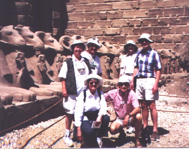
capitals. The Karnak Temple is a spectacular complex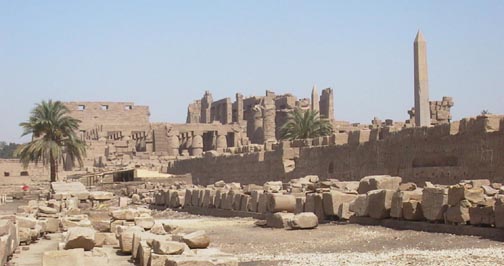 and was the largest religious city ever built. Construction of the
complex was started about the 19th century BC and the latest addition was in
the 4th century BC during the Greek era. Karnak means fortified place or castle
and was probably not the original name. Mostly the construction is of sandstone
and some granite. Karnak was the head of the Amun-Ra (sun god) worship. At the
peak of prosperity, about 82,000 people populated Karnak and provided all the
life services of marriages, taxes, schools, etc. Ra as a ram, a disc or a scarab
beetle is the official representative of Ra
and was the largest religious city ever built. Construction of the
complex was started about the 19th century BC and the latest addition was in
the 4th century BC during the Greek era. Karnak means fortified place or castle
and was probably not the original name. Mostly the construction is of sandstone
and some granite. Karnak was the head of the Amun-Ra (sun god) worship. At the
peak of prosperity, about 82,000 people populated Karnak and provided all the
life services of marriages, taxes, schools, etc. Ra as a ram, a disc or a scarab
beetle is the official representative of Ra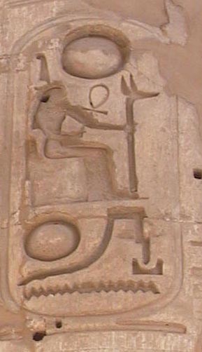 and if you want to talk to Ra you talk to the ram. The main entrance used to
run all the way to the Nile before the current road was built. Ramesses II thought
he would be the last Pharaoh adding to Karnak, yet every Pharaoh added to Karnak
including Seti II who built three shrines in the corner for Ra, Ra's mother
Mut and Khons, the son. Ramesses II, who ruled for 67 years, would usurp all
temples that he wanted by scratching out the cartouches of the original builder
and adding his own. Consequently, when Ramesses II
built anything, his cartouche was on every single column, wall, and capital;
thus no one could "scratch him out"! Ramesses III constructed a small
temple and the Nubian tribe from Upper Egypt conquered Karnak and built ten
columns, one of which survives today. In the hyperstyle hall there are 134 columns
and all used to be under one roof. The guides say that 100 people can stand
on the top of each capital on each column. Since this was the temple to the
most important god, Ra, it was the biggest and best temple, yet it was unfinished.
You can see the remains of a mud brick ramp, the only one left in existence,
showing how the outside wall was constructed. King Tut added two marble sphinxes.
The film, "Death on the Nile", was filmed here. In 1887, the Nile
flood covered the temple in water ten feet deep. Hatshepsut, a queen who ruled
for twenty years in lieu of her stepson, constructed two obelisks each weighing
300 tons. Her stepson, Tuthmosis, hated her and chiseled out all her faces and
surrounded one of her obelisks with a wall, which of course preserved it! For
a long period of Egyptian history, this area was built and rebuilt to commemorate
the victories of various pharaohs. There is a huge stone statue of a scarab
beetle, which is responsible for the sunrise, the beginning of the day, and
today could be thought as a symbol of resurrection. If you walk around the statue
clockwise, you will be fertile, counter-clockwise for fitness. We checked which
way we were all walking and walked around it once! There is also a sacred lake
used for purification and over 100 gates to the temple area. A large amount
of archeological and restoration work is evident at Karnak.
and if you want to talk to Ra you talk to the ram. The main entrance used to
run all the way to the Nile before the current road was built. Ramesses II thought
he would be the last Pharaoh adding to Karnak, yet every Pharaoh added to Karnak
including Seti II who built three shrines in the corner for Ra, Ra's mother
Mut and Khons, the son. Ramesses II, who ruled for 67 years, would usurp all
temples that he wanted by scratching out the cartouches of the original builder
and adding his own. Consequently, when Ramesses II
built anything, his cartouche was on every single column, wall, and capital;
thus no one could "scratch him out"! Ramesses III constructed a small
temple and the Nubian tribe from Upper Egypt conquered Karnak and built ten
columns, one of which survives today. In the hyperstyle hall there are 134 columns
and all used to be under one roof. The guides say that 100 people can stand
on the top of each capital on each column. Since this was the temple to the
most important god, Ra, it was the biggest and best temple, yet it was unfinished.
You can see the remains of a mud brick ramp, the only one left in existence,
showing how the outside wall was constructed. King Tut added two marble sphinxes.
The film, "Death on the Nile", was filmed here. In 1887, the Nile
flood covered the temple in water ten feet deep. Hatshepsut, a queen who ruled
for twenty years in lieu of her stepson, constructed two obelisks each weighing
300 tons. Her stepson, Tuthmosis, hated her and chiseled out all her faces and
surrounded one of her obelisks with a wall, which of course preserved it! For
a long period of Egyptian history, this area was built and rebuilt to commemorate
the victories of various pharaohs. There is a huge stone statue of a scarab
beetle, which is responsible for the sunrise, the beginning of the day, and
today could be thought as a symbol of resurrection. If you walk around the statue
clockwise, you will be fertile, counter-clockwise for fitness. We checked which
way we were all walking and walked around it once! There is also a sacred lake
used for purification and over 100 gates to the temple area. A large amount
of archeological and restoration work is evident at Karnak.
Esna Lock, the only lock on the middle Nile, is 54 miles south of Luxor in
the rural part of Egypt. In some places the livable part of Egypt is only nine
miles wide. The Temple of Esna, built during the Roman Emperor Claudius's time
to the God, Khnum, is now about 25 feet below the current street level as succeeding
civilizations built upon the ruins of previous towns. We stopped at this temple
on our return trip to Luxor. As we approached the two locks at Esna and while
waiting out turn, we were besieged by boatmen throwing up galabeyas, tablecloths,
and other garments for us to buy. They had excellent aim to get the "package"
up to the top deck. Some people did purchase items and threw their money back
by return "airmail" packages.
As we cruised up, or south, on the Nile we came to the Edfu Temple of Horus,
the largest pharaohnic temple built during the Greek time by Ptolemy III in
237 BC. The temple was buried with silt up to the level of the village and excavated
in the 19th century. Horus is the god of the sky and the son of Osiris and Isis.
Osiris's brother is Seth, god of the underworld and evil. During one of their
battles, Seth cut Osiris into many pieces and cast them over the land. Seth's
wife, Neptis, and Isis hunted for all the pieces and reconstructed Osiris. Horus,
the son, is shown as conquering Seth, but not killing him. Good and evil always
compete; good has evil under control but is aware that evil can come again as
something else. The Greek period of the Egyptian civilization was the conduit
by which many basic elements of the Egyptian culture were passed down to the
present time. Previous to this trip, on many occasions, we have thought how
the Greek and Roman cultures have impacted our civilization. Until this trip,
we little realized the influence of the Egyptians. Our southern terminal for
two nights on the boat was at Elephantine Island just north of the Aswan Dam
and the first cataract of the Nile. This was also the border of southern Egypt
during much of the pharaohnic period.
We had elected to go to Abu Simbel, which required us to be up at 4:15 am for
a plane at 7 am. Abu Simbel is 280 km to the south from Aswan and 40 km from
the southern border with Sudan. This land south of Elephantine Island is essentially
Nubia land or the land of the gold. In 1960, the Aswan dam was begun and required
the relocation of over 60,000 Nubians and at least 22 temples. The Abu Simbel
complex was cut into pieces and moved 200 meters latterly and 20 meters upwards
between 1964 and '68 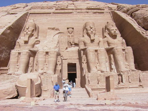 for
a total cost of $40 million. The Swedish, German, Italians, and French were
involved in the project. There were no roads, airports, or accommodations for
the 200+ workers who built the cofferdam and worked on the temple. Everything
had to be brought in and built first to start the project. 1,042 blocks weighing
20-30 tons each were extracted from the temples. A protective dome now surrounds
the rebuilt temple on higher ground, which was then covered with rock. Of course,
the outside looks like the original setting. There
are four statues of Ramesses II showing him with the double crown of Egypt (Upper
and Lower kingdoms). The statues on the left show him looking younger
while the statues on the right show him having aged. There are baboons across
the top, which celebrate the sunrise and mark each hour in the day. The inside
walls are richly decorated with engraved paintings of Ramesses on his chariots,
Ramesses attacking his enemies (the Nubians in the south and the Hittites in
the north) and a solar barque. The approach to the holy inner room is very interesting.
There is an obvious gradual incline to the floors and a decrease in the ceiling
height as you walk through the four rooms. As the temple was constructed, the
rays of the sun were calculated to strike the face of the statue of Ramesses
in the holy room on October 21st, Ramesses's birthday, and on February 21st,
the day he was crowned. At the new site, the sun lights the holy room one day
later - so much for modern technology. The nearby second temple, that was also
moved, was the small temple for Queen Nefertari, Ramesses II's major wife, and
the goddess Hathor. This temple features six statues: Ramesses, Neftari, Ra,
Ra's son, Neftari, and Ramesses. The walls were decorated with carvings of offerings
using great colors.
for
a total cost of $40 million. The Swedish, German, Italians, and French were
involved in the project. There were no roads, airports, or accommodations for
the 200+ workers who built the cofferdam and worked on the temple. Everything
had to be brought in and built first to start the project. 1,042 blocks weighing
20-30 tons each were extracted from the temples. A protective dome now surrounds
the rebuilt temple on higher ground, which was then covered with rock. Of course,
the outside looks like the original setting. There
are four statues of Ramesses II showing him with the double crown of Egypt (Upper
and Lower kingdoms). The statues on the left show him looking younger
while the statues on the right show him having aged. There are baboons across
the top, which celebrate the sunrise and mark each hour in the day. The inside
walls are richly decorated with engraved paintings of Ramesses on his chariots,
Ramesses attacking his enemies (the Nubians in the south and the Hittites in
the north) and a solar barque. The approach to the holy inner room is very interesting.
There is an obvious gradual incline to the floors and a decrease in the ceiling
height as you walk through the four rooms. As the temple was constructed, the
rays of the sun were calculated to strike the face of the statue of Ramesses
in the holy room on October 21st, Ramesses's birthday, and on February 21st,
the day he was crowned. At the new site, the sun lights the holy room one day
later - so much for modern technology. The nearby second temple, that was also
moved, was the small temple for Queen Nefertari, Ramesses II's major wife, and
the goddess Hathor. This temple features six statues: Ramesses, Neftari, Ra,
Ra's son, Neftari, and Ramesses. The walls were decorated with carvings of offerings
using great colors.
When we were visiting with Abu Simbel and Ramesses II, the other difference
of opinion that we have had with Egyptologists was addressed. In previous trips
that the fear-some foursome have made, we have found ourselves in the right
place, such as Jerusalem, Megiddo and Jericho, but in the wrong time for when
things were supposed to have occurred. The chronology problem arises from two
separate but interrelated problems with Egyptian and Eastern Mediterranean archeology.
The first is that Egyptologists list the reign of the pharaoh's chronologically
when we know that there were many periods when two and sometimes four pharaohs
ruled different parts of Egypt at the same time. The second problem is that
in about 1880 AD an eminent French archeologist, named Jean Francois Champollion,
linked Shoshenk I with the biblical king Shishank and the sacking of Jerusalem
during Year 5 of the reign of the Israeli King Rehoboam. This mistake was just
one of the false pillars that connected the Mycenaean Greece, Minoan Crete,
Hittite Anatolia and pre Solomon Israel for the past 110 years. We and many
others are convinced that Shoshenk and Shishank (Ramesses II) were two different
people who lived about 332 years apart and that Ramesses II was the pharaoh
that sacked Jerusalem in about 925 BC. On 9 May of 1,012 BC a total Solar Eclipse
occurred and was recorded in many countries in the Eastern Mediterranean. In
addition, the Amarna Letters and the Nileometer logs of flood levels and pharaohs
provide collaboration and correlation to the corrected Pharaoh list of the new
chronology. Table 1 provides some insight into the errors
of the Egyptian chronology during a historical time for both Egypt and Israel.
Weather in Upper Egypt on the cruise ship is very hot and dry, sometimes exceeding
105oF. We are up early in the morning to see the sites, return to the ship for
lunch, and later in the afternoon visit more temples. Fortunately, the ship
had a lovely small pool, which we frequented each day. We were supposed to have
a ride on a felucca around Elephantine Island, the location at one time of the
palaces of the pharaoh of Upper Egypt. This is also the location of the first
of six cataracts on the Nile. A dam built by the British is just up stream and
a few miles beyond is the Aswan Dam and Lake Nasser, the world's largest man
made lake. The weather was hot and there was no wind, so we were rescheduled
for a motorboat ride instead of a felucca. The "motorboat" held all
30 of our group. Nubian tribal people run the boats and sell their crafts such
as camel bone necklaces and letter openers. The crew also played a goatskin
drum and sang to entertain us during the boat ride.
The biggest loss because of the Aswan high dam was the loss of Nubian temples
and lands. Some of the temples were moved. Other negatives about the dam include
the fact that the fertile silt of the Nile is not distributed anymore downstream;
the water table is rising which affects all the temples on the shores of the
Nile; the yearly flooding "washed" the land and got rid of the accumulated
salts; the weather in "Upper" Egypt has changed because of the evaporation
and humidity caused by Lake Nasser; and there are less fish in the lower part
of the Nile. Silt has accumulated in Lake Nasser, but they are starting a project
to mine the silt and redistribute it by a new canal above the Aswan Dam into
the Western desert. Some of the positives for the dam include the protection
against floods; protection during drought; produces 1/3 of Egypt's electricity;
irrigation water is available all year long and has doubled the amount of land
in food production; Nile is navigable all year long; and the lower Nile is safe
from crocodiles.
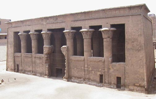
At Aswan, we visited the Temple of Philae built in the 6th century BC. This
temple was also relocated from Philae to Agilika island to save it from the
flooding of the Aswan dam. This temple was one of the last places where the
ancient Egyptian religion flourished. Justinian closed the temple in 550 AD
and the temple was eventually converted to a Christian church and then became
a Coptic church. The temple is also known as the Temple of Love or Isis, the
maternity goddess and source of everyday life. On one of the structures was
a cute small dwarf god of fun with a big belly, Bess, and he helps women during
the birthing process. The Nile originates from the tears of Isis, the mother
of Horus and wife of Osiris. The Roman, Trajan, added an addition to the temple
of Greek style columns in the 1st century AD. Later, Trajan took the spoils
from the sacking of Jerusalem and built the Coliseum in Rome.
We stopped at the Ani Papyrus factory in Aswan and learned how papyrus is made.
The stalk is peeled and sliced vertically and soaked in Nile (holy) water for
six to ten days depending on the darkness of the color desired. The slices are
then arranged horizontally and vertically and pressed for six days, which produces
a very flexible paper. We purchased a papyrus based painting showing the Ducks
of Maydoom, a village near Lake Moeris which we didn't visit. The Ducks of Maydoom,
created in 2,400 BC, exhibit perfection and beautiful colors. Our copy was made
rather recently and came in several sizes. Dick and Christine purchased a papyrus
showing a scene of the Nile River with the papyrus of the North and the lotus
blossom of the South.
On our return cruise downstream from Aswan to Luxor, we visited Kom Ombo Temple.
The site is located on a east bank hill overlooking the Nile. This is the only
double temple, dedicated to Sobek, the crocodile god, and Haroeris the great
winged solar disk. In one building we saw three mummified crocodiles. Everything
is double from the twin entrances, twin courts and twin colonnades. We saw beautiful
colors in one ceiling of vulture wings, which is representative of the South.
The Greeks worship Inhotep as the god of medicine and there is a list of surgery
tools carved on the walls. The best-preserved ancient hospital at Dundra is
near Luxor. Why are the figures of the ancient Egyptian people always shown
in profile? The reason is to show each part of the body in its best light. In
addition, the profile can denote motion and motion tells a story. The head,
breast, and legs are shown in profile while the eye, shoulder, and belly button
are shown as a frontal view. The biggest Nileometer, which measures the flood
level of the Nile, was found here. Of course "cubits" and not meters
were used to measure distance. The Nileometer played a role in predicting the
level of the flood and was used to set the level of the taxes of the resulting
crops. To repeat the story-If there was a big flood, small taxes because the
crop could not be planted; if a drought, low taxes because there would be a
bad crop; and if there was a medium flood, high taxes because the proper silt
produced the best yield.
 Esna
Temple, the best example of Greco-Roman building in Egypt, was built
in the 2nd century BC and finished in 2 AD. The temple is now 25 feet below
the current ground level of the city and ground water effect on the limestone
is a major problem at this temple. This temple was dedicated to Khnum, the god
of the flood. Khnum has the head of a ram with horns in a straight horizontal
line, whereas Ra's horns are curly. Khnum created men and animals from Nile
clay. The ceiling of the temple represented the sky; the capitals of the columns
are all different like trees and flowers in a garden; the floor of the temple
represents the earth; on the wall is the water; and on the wall is the creation
of the human being.
Esna
Temple, the best example of Greco-Roman building in Egypt, was built
in the 2nd century BC and finished in 2 AD. The temple is now 25 feet below
the current ground level of the city and ground water effect on the limestone
is a major problem at this temple. This temple was dedicated to Khnum, the god
of the flood. Khnum has the head of a ram with horns in a straight horizontal
line, whereas Ra's horns are curly. Khnum created men and animals from Nile
clay. The ceiling of the temple represented the sky; the capitals of the columns
are all different like trees and flowers in a garden; the floor of the temple
represents the earth; on the wall is the water; and on the wall is the creation
of the human being.
After six days, our ship arrived back at Luxor where we spent the next day exploring
the Valley of the Kings and Queens. The west bank of the Nile has the tombs
for the pharaohs, while the east bank is where the palaces and temples are located.
Life on the east bank, death on the west…very simple separation. That the
tombs were ever found is amazing because when they were built they were dug
into the ground or hillside. They were intended to be private burial sites for
the pharaohs. 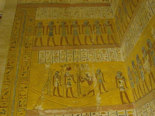 On
the walls of most of the tombs is inscribed the Book of the Dead, that contains
all the instructions the pharaoh needed to negotiate the trip to the afterworld,
the passwords needed, and the offerings required. There are
On
the walls of most of the tombs is inscribed the Book of the Dead, that contains
all the instructions the pharaoh needed to negotiate the trip to the afterworld,
the passwords needed, and the offerings required. There are 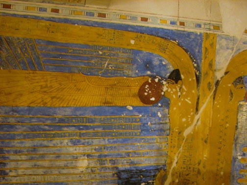 24
gates to cross when you die and each one needs a password. In addition, the
Book of the Dead is on scrolls stored in the tomb. The walls
and ceilings are richly painted and
carved to praise the pharaoh's life showing him defeating his enemies.
Always depicted is the weighing of the heart to make sure that the heart is
as light as a feather meaning the pharaoh has been good and is allowed to go
to the afterworld and not to the underworld. The entrances into many of the
tombs proceed down a long set of stairs at a 45 degree slope where you finally
come to the crypt. The sarcophagus is a set of eight coffins, one inside another.
The last sarcophagus is solid gold, which signifies eternity. The mummification
process requires 70 days during which the major organs (stomach, intestines,
liver, lungs) were removed and placed into four jars. The heart is left in the
body. The brain is removed and thrown away as it was not considered a major
part of the body. If the pharaoh dies before the tomb is either built or finished,
a tomb is quickly finished, not as beautifully painted or enriched, within the
70 days. The ancient Egyptians believed that life in the tomb was eternal and
all servants and needs should be contained within the tomb to make the pharaoh's
life easy.
24
gates to cross when you die and each one needs a password. In addition, the
Book of the Dead is on scrolls stored in the tomb. The walls
and ceilings are richly painted and
carved to praise the pharaoh's life showing him defeating his enemies.
Always depicted is the weighing of the heart to make sure that the heart is
as light as a feather meaning the pharaoh has been good and is allowed to go
to the afterworld and not to the underworld. The entrances into many of the
tombs proceed down a long set of stairs at a 45 degree slope where you finally
come to the crypt. The sarcophagus is a set of eight coffins, one inside another.
The last sarcophagus is solid gold, which signifies eternity. The mummification
process requires 70 days during which the major organs (stomach, intestines,
liver, lungs) were removed and placed into four jars. The heart is left in the
body. The brain is removed and thrown away as it was not considered a major
part of the body. If the pharaoh dies before the tomb is either built or finished,
a tomb is quickly finished, not as beautifully painted or enriched, within the
70 days. The ancient Egyptians believed that life in the tomb was eternal and
all servants and needs should be contained within the tomb to make the pharaoh's
life easy.
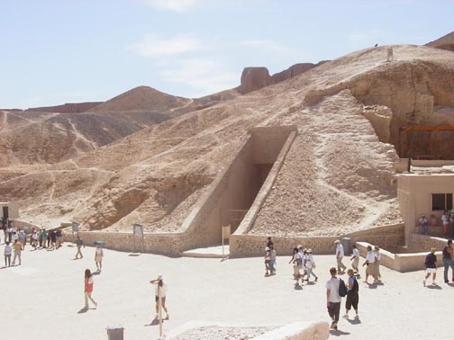 We
were able to tour three tombs in the Valley of the
Kings - Ramesses IV (13th century BC), Ramesses IX, and Merenptah
- and we toured one tomb in the Valley of the Queens. We also saw, but did not
tour the tomb of King Tut and Hatshepsut's Temple which is a copy of a 19th
century BC temple that the Queen liked. This is a funerary temple and is not
dedicated to any god. Our last tour stop in Egypt was the Luxor museum, a rather
new, but small, museum with quality artifacts such as an exquisite pink granite
statue of Amenhotep III, the grandfather of Tut, and also the recent statues
and other items found in 1989 under the main plaza floor of the Luxor Temple.
On our last night aboard ship, we had a farewell dinner. Very nice-good crew!
During our cruise, sand in the air limited our view of the stars at night. The
following morning, the entire group left the ship and flew back to Cairo where
we stayed overnight at the Movenpick Hotel in Heliopolis near the airport. The
majority of the tour group was returning home to the states after midnight,
but we were continuing on to Jordan for five days. The next day, as discussed
earlier, the two of us and Dick took a taxi and went back to the Giza plateau
to reassess the Pyramids and the Sphinx up close and personal. This was quality
time and we wish we had had an opportunity to do this at other sites that we
had visited in Egypt. So little time---so much to see and do!
We
were able to tour three tombs in the Valley of the
Kings - Ramesses IV (13th century BC), Ramesses IX, and Merenptah
- and we toured one tomb in the Valley of the Queens. We also saw, but did not
tour the tomb of King Tut and Hatshepsut's Temple which is a copy of a 19th
century BC temple that the Queen liked. This is a funerary temple and is not
dedicated to any god. Our last tour stop in Egypt was the Luxor museum, a rather
new, but small, museum with quality artifacts such as an exquisite pink granite
statue of Amenhotep III, the grandfather of Tut, and also the recent statues
and other items found in 1989 under the main plaza floor of the Luxor Temple.
On our last night aboard ship, we had a farewell dinner. Very nice-good crew!
During our cruise, sand in the air limited our view of the stars at night. The
following morning, the entire group left the ship and flew back to Cairo where
we stayed overnight at the Movenpick Hotel in Heliopolis near the airport. The
majority of the tour group was returning home to the states after midnight,
but we were continuing on to Jordan for five days. The next day, as discussed
earlier, the two of us and Dick took a taxi and went back to the Giza plateau
to reassess the Pyramids and the Sphinx up close and personal. This was quality
time and we wish we had had an opportunity to do this at other sites that we
had visited in Egypt. So little time---so much to see and do!
We arrived in Amman the next evening and stayed overnight at the Holiday Inn.
Our guide, Anas, met us at the airport. He is a young, 29 year old, who was
quite good and knowledgeable about his country and how Jordan plays on the international
table of good guy and bad guy among nations. Our first day would be a very long
day with a bus ride to Petra in the southern part of the country. Amman is a
very modern spread out city and very clean. The drivers even obey traffic signals!
The cars are newer and there is not as much traffic or traffic noise as in Cairo.
Across the street from the hotel, there was a kids driving course where they
used little cars and learned the traffic signals. In addition, the course was
used to teach kids how to cross the street because of a high accident rate when
cars started to be more numerous than horses and donkeys. Amman's population
is one fifth of the country's population of five million.
Jordan is known as the Hashemite Kingdom of Jordan. Hashemite, sons of Hashem
is the tribe of the King and originated in the Mecca area. The King is now Abdulla,
who succeeded his father, King Hussein. Jordan is surrounded by Israel, Egypt,
Saudi Arabia, Iraq, and Syria. Arabic is the official language, yet English
is taught in all the schools. Jordan gets free oil from Iraq and sided with
that country in the Gulf War. Islam is the religion of 95% of the people with
the other 5% being Christians (Roman Catholic and Greek Orthodox). One of the
major north-south roads is the King's Highway (Route 35). We traveled this road
the first day. The road is the main route for Iraq goods to the Port of Aqaba
and has much truck traffic. Tourism is #1 in Jordan or 17% of the GNP with many
of the tourist coming across the Jordan from Israel. Tourist has increased 12-fold
over the last ten years. The northern part of Jordan is the breadbasket with
the milder temperatures and rain allowing them to grow fruits, vegetables, olives,
and barley. Jordan only needs to import rice and wheat, otherwise the country
has sufficient food. 80% of the country is arid. The people of the desert, the
Bedouins, comprise 1% of the population. They live in tents of camel hair and
move for weather and water. By 1975 more than 20% were semi-Bedouins, who have
settled in villages. Bedouins make their living from sheep and goats. Their
main transportation was camels, however, now they are white Toyota pickups with
black license plates that frees them from paying taxes. Today's Bedouins are
represented in parliament with five seats and their chiefs have the political
and religious power. There are schools and medical centers in the Bedouin villages.
Jordan's economy over the last fifteen years has been hurt because of the Gulf
war, the embargo on Iraq, and the Israeli/Palestinian conflict.
Madaba is the city of carpets, the city of Christians, and the city of mosaics.
During the Byzantine era of the 4-7th century AD, when the Romans converted
to Christianity, Madaba was the main city of the Jordan area. We stopped at
the Greek Orthodox Church where there is a 1,400-year-old mosaic map of the
holy land on the floor. The church was restored in 1895 and fortunately the
7x18 meter mosaic floor was saved. The floor is a topographical and holy map
showing the walled city of Jerusalem, Bethlehem, Hebron, Ashdod, Aeskelon, Egypt,
and the Nile. Several archeological findings of biblical sites in Jordan were
discovered using this map.
Mt. Nebo is the memorial site to Moses. The Byzantine Church has beautiful
mosaic floors from the 6th century AD. The tradition is that Mt. Nebo is where
God took Moses to see Israel. There are images of people and animals in one
of the floors, but this mosaic floor was preserved when a second floor was built
on top. There was a time in early Christianity when religious fanatics, who
held that images of people were sinful, destroyed many mosaics. From Mt. Nebo,
on a clear day, you can see the Sea of Galilee and the Jordan River, but there
was lots of sand in the air when we were there. We stopped at a mosaic school
where they briefly showed us how they make mosaics. This was really a toilet
and shop stop. As we drove further south, we stopped to see the "Grand
Canyon" of Jordan, Wadi Mujib (Wadi Aaron in the Bible), which lies 2,000
feet below us. This is an east-west wadi, a dry riverbed or valley that ends
at the Dead Sea. This valley is part of the Great Rift Valley that extends from
Turkey to Kenya and is the junction of the Arabian and Sinai plates. Jordan
is building a dam across the riverbed that lies in this wadi. The road across
the wadi is a two lane curvy road, mostly without guardrails and took us 30
minutes to drive the 15 miles across the valley. We saw some Roman milestones
that were used as signs for those traveling between Jerusalem and Mt. Nebo.
We eventually stopped on the next plateau at Al Mujeb Hotel, which is the only
place around, for a buffet lunch.
After lunch, we toured Karak Castle. Crusaders captured Jerusalem in 1096 AD
and built Karak in 1142 AD. This is the largest of the three Crusader castles
(Petra, Karak, and Amman) in Jordan. Pope Urban asked the Crusader armies to
protect the Christian sites and these castles strategically protect the eastern
heights of Jerusalem from Arab attack. Richard the Lion Hearted and Salladin
fought at Gallilee. Salladin was the winner and proceeded to seize the castle
at Karak in 1189. During the 12th and 13th centuries, these Crusader castles
were enlarged. During the 1700-1900's the Turks used the castle as a prison.
On a clear day you can see the Dead Sea and Masada.
The area in the south of Jordan is very arid and desert-like. Potash is mined
from the top surface of the land leaving the landscape with piles of dirt. Our
afternoon drive to Petra was long and tiring. There is a lot of commercial truck
traffic on the road hauling water, grains, and foods. We finally arrived at
the Petra Plaza Hotel located about three miles from Petra. The hotel has been
recently bought and is undergoing reconstruction by Marriot. There are about
45 hotels in the area and, during the high tourist season, an average of 4,000-people/day
visit Petra! Because of the Israeli/Palestinian conflict, tourism is down considerably.
Our hotel overlooks the western mountain range, which hides the city of Petra.
We were up early the next morning to spend the entire day at Petra. We drove
down through the small town of Wadi Musa and parked at the Visitor Center. Anas
gave us an overview of the Nabateans, their culture and their city. The Nabateans
were nomadic Arabian tribes, which came from Yemen around the 6th century BC.
During the 4th century, they were surrounded by Greeks, Romans, and Egyptians
and became involved in caravans. They offered safe passage to the caravans as
they crossed from the Far East to the trading centers on the Mediterranean.
Two of the precious items were frank-incense and myrrh which were important
for Greek and Egyptian funeral rituals. These are syrups from trees, which hardens
into a resin and is used as incense. The Nabateans mined tar or bitumen from
the Dead Sea and traded it with the Egyptians who needed it for the mummification
process. The peak prosperous time for the Nabateans was from 250 BC to the 2nd
century AD. In 106 AD Petra started to decline and Trajan, the Roman ruler,
annexed Petra to the Roman Empire. He paved the King's Highway, and moved the
frank-incense trade routes away from Petra. The Romans also moved the capital
from Petra to Bastra in Syria and with the shift in the trade routes the Nabatean
Empire and the fate of Petra declined until it became the "lost city".
There are over 800 caves in Petra containing the tombs of the Nabateans. Bedouins
lived here from 1700-1985. The Swiss "discovered" Petra in 1812 and
excavations began in 1930. Take
a tour and read about Petra at the Brown University Petra website.
An earthquake or river cutting through the sandstone created the ravine or
siq leading into Petra. We walked about a mile, on a gentle downhill slope,
through the siq admiring the soaring walls, the fantastic shapes, beautiful
colors, and the two water systems built by the Nabateans. One of the gravity
water systems is a channel carved in the rock and covered with flat stone. The
second water system is a clay pipe secured to the other side of the sandstone
walls bringing spring water from the Springs of Moses ten miles to the other
end of the city. There are 25 niches and carvings along the walls of the siq.
In some places the path is twenty feet wide, in others it is as narrow as eight
feet. Only small carriages with a single horse are allowed to transport people,
who have trouble walking, through the siq. Back in 1978, visitors were able
to ride into the city on horseback. However, as the weather heated up and tourism
increased you can imagine the smell of the horse droppings overwhelming the
narrow ravine. Jordan did a wise thing in eliminating this heavy horse traffic.
The siq is now a nice restored walk through time.
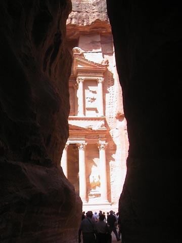 As
we approached the end of the siq, our guide asked us to close our eyes and hold
hands so that we would appreciate the dramatic, startling, and famous
view of the Treasury building or Khazneh. In the dazzling sunlight,
the sides of the ravine frame the Treasury. As they say "timing and weather
are everything". In our case, both were perfect. The Treasury
building is a huge two-story building (120 feet in height and 85 in width) carved
into the sandstone, ornate columns and statues on the outside
As
we approached the end of the siq, our guide asked us to close our eyes and hold
hands so that we would appreciate the dramatic, startling, and famous
view of the Treasury building or Khazneh. In the dazzling sunlight,
the sides of the ravine frame the Treasury. As they say "timing and weather
are everything". In our case, both were perfect. The Treasury
building is a huge two-story building (120 feet in height and 85 in width) carved
into the sandstone, ornate columns and statues on the outside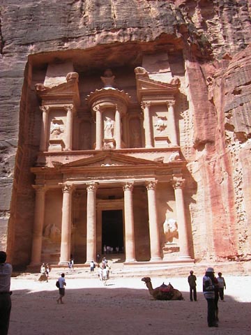 and large rooms with square corners on the inside. Scaffolding holes were noted
on each side. There is a funerary jar on the top of the Treasury. The statue
of Isis is in the top middle, underneath the funeral jar. To the left and right
are winged Amazons and eagles. There is a large rock face outcropping overtop
of the façade and another at the right, which has sheltered and protected
the Treasury from the wind and rain over the years. Beyond the Treasury the
gorge narrows once again and finally opens out into a large valley where the
palaces, baths, theater, and private homes of the city existed along the hillsides.
The original creek bed for floodwater winds its way through the valley. The
beauty of Petra is in the tombs of the royalty carved into the sandstone cliffs
and mountains. Even though about 40,000 people once lived in Petra, the homes
are gone for they were just mud brick buildings. The same thing happened to
the old Egyptian cities. We didn't climb the long path to the High Place of
Sacrifice, which stands above the entire city, but Dick and Christine had done
this back in 1963 (in their younger days!). The
and large rooms with square corners on the inside. Scaffolding holes were noted
on each side. There is a funerary jar on the top of the Treasury. The statue
of Isis is in the top middle, underneath the funeral jar. To the left and right
are winged Amazons and eagles. There is a large rock face outcropping overtop
of the façade and another at the right, which has sheltered and protected
the Treasury from the wind and rain over the years. Beyond the Treasury the
gorge narrows once again and finally opens out into a large valley where the
palaces, baths, theater, and private homes of the city existed along the hillsides.
The original creek bed for floodwater winds its way through the valley. The
beauty of Petra is in the tombs of the royalty carved into the sandstone cliffs
and mountains. Even though about 40,000 people once lived in Petra, the homes
are gone for they were just mud brick buildings. The same thing happened to
the old Egyptian cities. We didn't climb the long path to the High Place of
Sacrifice, which stands above the entire city, but Dick and Christine had done
this back in 1963 (in their younger days!). The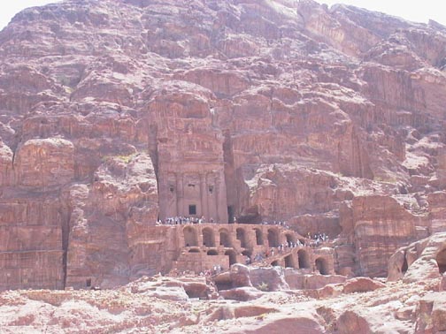 Royal Tombs consist of four large structures carved
into the rock face and we did climb up and walk through them. The
Urn Tomb faces out over an open terrace with a colonnaded cloister.The Corinthian
tomb has columns, the Palace Tomb resembles the Treasury, and the Silk Tomb
had beautiful colors. Arches were added later when this was used as a Byzantine
church. The wall and ceiling interiors of the rooms
are beautifully colored because of the oxidation that has occurred.
In many cases, we are walking on the original limestone pavement stones.
Royal Tombs consist of four large structures carved
into the rock face and we did climb up and walk through them. The
Urn Tomb faces out over an open terrace with a colonnaded cloister.The Corinthian
tomb has columns, the Palace Tomb resembles the Treasury, and the Silk Tomb
had beautiful colors. Arches were added later when this was used as a Byzantine
church. The wall and ceiling interiors of the rooms
are beautifully colored because of the oxidation that has occurred.
In many cases, we are walking on the original limestone pavement stones.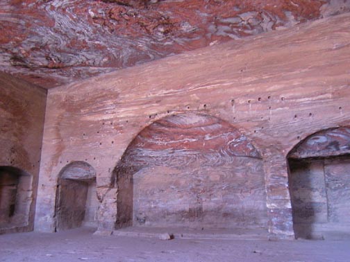 There is a large Roman Amphitheater carved out of the rock that is being restored
and protected from damage. When Dick and Christine were here in 1963 the lower
six rows of seats hadn't been excavated. Since then they were uncovered in 1967.
Brown University has an extensive long-term dig of an acropolis area.
There is a large Roman Amphitheater carved out of the rock that is being restored
and protected from damage. When Dick and Christine were here in 1963 the lower
six rows of seats hadn't been excavated. Since then they were uncovered in 1967.
Brown University has an extensive long-term dig of an acropolis area.
We continued walking to the other side of the city for a total distance of
2.5 miles or a round trip of 5 miles. We walked by a colonnaded street, another
of Trajan's arches, and a Nabatean temple. After lunch, we explored the little
museum and other sites before taking our time returning to the Visitor Center.
The day was a beautiful 90-degree day. There are only two bathrooms available
to the tourists (10 toilets in total!), one just beyond the amphitheater and
the other at the restaurant at the end of the city. The towns and villages around
Petra are undergoing major road construction to put in place a major drainage
system and new access roads. When the rains come, water pours down the mountains
and funnels into the siq causing flash floods. Switzerland has given Jordan
the money to build the drainage systems to divert the water because some Swiss
citizens were drowned during one of the flash floods. The mountains around Petra
rise to 4,000 feet and do get snow in the winter.
After leaving Petra the next morning, we returned to Amman via the main highway,
but we first stopped at the Dead Sea, for an hour swim and lunch. Floating in
the Dead Sea with its high salt content (37%) is quite an experience. Your feet
and body are bobbing on the surface. Because the Jordan River flowed into the
Dead Sea only a few miles from where we went swimming, the salinity was not
as great as where we had swam on the Israeli side in 1977. We were able to walk
into the Dead Sea to a depth of about four inches greater than our last experience
before our feet just bobbed to the surface and we floated. The Dead Sea is 1,250
feet below sea level, the lowest point on the earth. We next toured a Roman
amphitheater in Amman, which seats about 1,000 people. The theater, constructed
in 165 AD by Marcus Aurilus, is now used for special events. Unfortunately,
much of the original Greek-Roman city of Amman is under the present part of
the "new" city.
We visited the citadel hill, which is the upper portion of the acropolis of
the town when it was known as Philadelphia. A temple, a Byzantine church, the
Umayyad complex, and the Museum of Archeology is on this hill. The Museum is
a small, but quality museum displaying artifacts from the stone age, bronze,
iron, and Roman ages. In addition, pieces of the Dead Sea scrolls, 1st century
AD, are on exhibit. The museum contained pre-pottery Neolithic statues dating
to 7000 BC and stele of King Mesha of Moab dating 850 BC, which is the first
eyewitness account of the history of Jordan in the Moabite language. We stopped
briefly at Ajloun, a 12th century AD castle (90 minutes north of Amman) built
by the Moslems to defend against the crusaders. This is the third castle of
the three in Jordan. The castle was built in this area to protect the fertile
lands. A 6th century mosaic floor, which had been the floor of a church, is
preserved in the castle.
We were not prepared to appreciate the ruins of the
Roman city of Jerash, 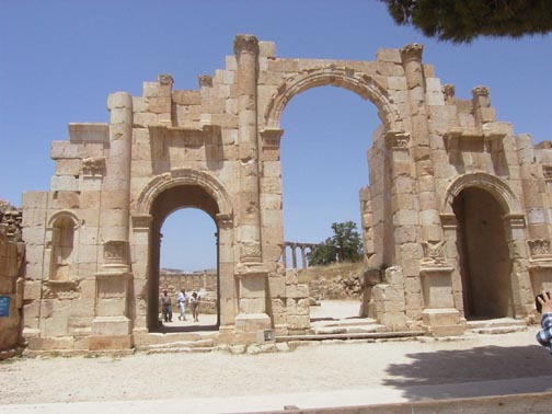 which
lies in the mountains of Gilead (or Ajloun). The remoteness of the city protected
the site for the most part from being used as a quarry. The city, about 40 minutes
from Amman, is one of the most complete examples of a Roman city to be seen
anywhere. In utter awe, we walked the walk and gawked the gawk through this
once beautiful and thriving city. We saw another of Hadrian's famous Arches,
the hippodrome, the Temple of Zeus, the amphitheater, Artemis's Temple (Diana)
with the finest Corinthian columns, and finally the many columns of the oval
plaza and main streets. On the original streets, we saw the wheel marks of chariots
and drainage holes on the sides to collect water. The amphitheater holds over
3,000 people for yearly concerts. At the end of July there is a large cultural
and art festival. In the visitor's center, we read that the Edict of Theodosium
(386 AD) by Bishop Theodosius permitted (and encouraged) the destruction of
pagan temples! In several places we saw how this "conversion" of a
building from one culture to another was the only reason that the structure
survived from being just another quarry for readily available building stone.
The bottom line on Jerash is that this city is an archeological treasure and
the archeological work has just begun and may never end. Entire sections of
the site have yet to be even surveyed for possible archeological content. Our
time there was much too short.
which
lies in the mountains of Gilead (or Ajloun). The remoteness of the city protected
the site for the most part from being used as a quarry. The city, about 40 minutes
from Amman, is one of the most complete examples of a Roman city to be seen
anywhere. In utter awe, we walked the walk and gawked the gawk through this
once beautiful and thriving city. We saw another of Hadrian's famous Arches,
the hippodrome, the Temple of Zeus, the amphitheater, Artemis's Temple (Diana)
with the finest Corinthian columns, and finally the many columns of the oval
plaza and main streets. On the original streets, we saw the wheel marks of chariots
and drainage holes on the sides to collect water. The amphitheater holds over
3,000 people for yearly concerts. At the end of July there is a large cultural
and art festival. In the visitor's center, we read that the Edict of Theodosium
(386 AD) by Bishop Theodosius permitted (and encouraged) the destruction of
pagan temples! In several places we saw how this "conversion" of a
building from one culture to another was the only reason that the structure
survived from being just another quarry for readily available building stone.
The bottom line on Jerash is that this city is an archeological treasure and
the archeological work has just begun and may never end. Entire sections of
the site have yet to be even surveyed for possible archeological content. Our
time there was much too short.
Our final dinner in Jordan was at the Al Kamzan Village, an old 19th century
village that was reconstructed to house a craft center and restaurant in an
old stone stable. We were reluctant to leave this very nice place to spend our
last night in Jordan back in the Holiday Inn. Unfortunately for some of our
group, they just ate dinner and got back on the bus. We stayed for the music
and drank in the atmosphere. The next morning, we flew back to Cairo and got
a day room at the Swissotel Hotel near the airport. We only had time for a swim
and dinner before we were again wisked away to the airport. Our flight for New
York in another EgyptAir Boeing 777 left at 1:30 in the morning. We arrived
back in New York at 6 am. Because we only had carry on luggage, we cleared customs
and found the next plane home. We flew to BWI and were home by 10:30 am.
The four of us thoroughly enjoyed this trip and are looking forward to another
one together! As Amin our guide in Egypt said, "In Egypt, you are not on
a holiday but on a mission". We truly were! Mission complete and now this
trip report is also completed.
John & Carolyn and Dick & Christine
References:
1) Gibson /McHale paper on Questions on Egypt researched
from the book Fingerprints of the Gods by Graham Hancock
2) Fingerprints of the Gods by Graham Hancock
3) Pharaohs and Kings David Roth
4) History of Egypt-James Breasted
Date revised: 8/21/01